Soil evaluation and sustainable farming methods
Bihar is situated on the World’s fertile alluvial plain of Gangetic Valley which extends from the foothills of the Himalayas in the north to a few miles south of the river
Ganges as it flows through the State from the west to the east. Variation in relief, precipitation, vegetation, and parent rocks have resulted in various soil varieties due to the region relief features. The foothills of Kaimur consist of alluvial soil and are naturally fertile. But the soil becomes harder as one proceeds southwards. As one moves up the foothills, the soil becomes stony and poor in fertility. The Kaimur plateau is an undulating tableland having thin shrub jungles and the land is not very fertile. The proposed
work is to be undertaken for the analyses of the soil for its physical state, its constituents and the nutrients, present in the soil. Different physio-chemical characteristics of the Kaimur (formerly known as Bhabua) region of Bihar State have been determined using standard methods.
Bhabua district, located in the extreme south-western part of the State extends between the north latitudes 24 0 -54’ and 250 -20’ and east longitudes 83 0 -20’-00” and 83 0 -40’ and falls in the Survey of India toposheet no. 63 O and P. Kaimur district is a part of Patna division.
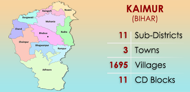
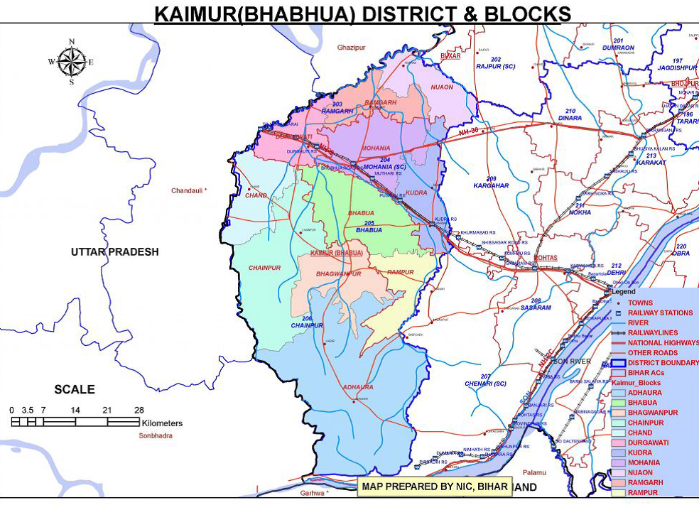
The district is bounded in the north by Buxar district of Bihar and Gazipur district of Uttar Pradesh, in the south by Garhwa district of Jharkhand State, in the east by Rohtas district of Bihar and in the west by Chandauli and Mirzapur district of Uttar Pradesh. The present Bhabua district was formed out of the Rohtas district in the year 1991. As per the Census, the total population of the district stands at 1,626,384 with a population density of 488 persons per SqKm.The total geographical area of the kaimur district is 3362 sq.km. The two Sub Divisions of kaimur i.e. Mohania subdivision, Bhabua subdivision and 11 Blocks i.e. Bhabua, Ramgarh, Mohania, Durgawati, Adhaura, Bhagwanpur, Chand, Chainpur, Kudra, Rampur, Nuawon.
The present Kaimur district was formed out of the Rohtas district in 1991. The district covers an area of about 3,40,447 hectares (2,830 km2). Geographically, the district can be divided into two parts viz. (i) Hilly area and (ii) Plain area. The hilly area comprises of Kaimur plateau. The plain area on the western side is flanked by the rivers, the Karmanasha and the Durgawati. The district has close linkage with the history of Shahabad, which was its parent district also. The old district of Shahabad had four subdivisions of which Bhabua was one. The present district of Kaimur has been formed from the whole of this Bhabua subdivision. The climate of the district is of moderately extreme type. It becomes quite hot during summer and fairly cool during the winter. The district gets maximum rains during month of July and August, being the rainy months of the year. There is a slight rainfall in October. Some winter rain occurs in January and February. The month of July gets the maximum rainfall. Average rainfall is 777mm.
CONNECTIVITY National Highway 2 (G.T. Road) crosses through Mohania Town and Kudra. Bhabua Road Railway Station is situated on Grand Chord Railway line. Bhabua (the district headquarters) is 14 km southward from the Bhabua Road railway station. The famous Mundeshawari Devi Temple which is the ‘oldest functional’ temple of world is about 10 km south to Bhabua.

TOPOGRAPHY
Kaimur has a very undulating topography and can largely be divided into two area viz.-
Hilly area
Plain area
The hilly area that covers the eastern Kaimur comprises of Kaimur plateau. The plain area that lies on the western side is bestowed with two rivers Durgawati and Karmanasha. The Kudra River lies on it eastern side. Sands found on the banks of river Durgawati and the Kudra are extensively used as building material. There is a possibility of finding limestone, sulphur and pyretic iron ores on the Kaimur hilly area.
CLIMATE & RAINFALL
The climate of the district is somewhat extreme in nature, i.e., quite hot during the summer and fairly cold during the winter. January is the coldest month when the mean minimum temperature comes down to approximately 4-degree C. The temperature starts rising from March and reaches its peak in May when the mercury touches about 450C. Rain starts sometime in mid-June and lasts till mid-September. The district gets easterly winds from June to September, and from October to May wind direction reverses. Maximum rains occur during the months of July and August (289 mm). Sometimes winter rains occur in Jan February.
LAND USE, AGRICULTURE & IRRIGATION PRACTICES
The alluvial plain extending up to the foothills of Bhabua ranges is extensively cultivated. Rice, wheat, pulses are the chief crops and the area is dotted with bamboo clumps and mango orchards. The plateau is generally covered with long grasses- Kush and Khas. Sal trees of poor quality and vast stretches of bamboo are also found. Firewood, Tendu leaf and Chiraunji are the important forest products.
FOREST AND WILDLIFE
Kaimur District with forest area of 1,13,403 Ha in which 98,644 Ha forms Kaimur wild life sanctuary. Forest is rich in medicinal plants and many village are situated in between the forest. The forest is protected with the help of tribes who are living in the sanctuary. The forest is dry deciduous in nature and few areas have dense growth of trees. Animals like the Leopard, Hyena, Jackal, Wolf, Wild Boar, Chowsingha (four horned antelope), Sloth Bear, Black Buck, Cheetal, Sambhar, Nilgai, Jungle Fowl, Python, Mugger, Langur, Monkey and more than 100 bird species are the species of vital importance in Kaimur Wildlife Sanctuary, which includes endangered species like Leopard, Black buck, Chinkara, Four horned antelope.
AGRICULTURE CALENDAR
Agricultural seasons are identified on the basis of sowing and harvesting of particular crops. Virtually agricultural seasons are crop seasons. Four agricultural seasons have been identified in the study area, viz., Bhadai, Aghani, Rabi and Garma. The Kharif season includes the Bhadai and Aghani crops starting with the advent of the monsoon, generally in the second week of June. The principal Kharif crops are rice, maize, ragi, tur, sugarcane. These crops are generally produced with the help of irrigation. Rabi is known as the season of winter crops which are sown in October and harvested in March and April. The crops of this season are wheat, gram, linseed, rapeseed and mustard. As during this season the rainfall is meagre and highly variable, most of the Rabi crops rely either on the moisture available in the soil after the monsoon rains or irrigation from various sources. The fourth one is Garma, it is sown in between the Kharif and Rabi crops. It generally covers onion and vegetables. Cropping pattern of the area is primarily determined by the four natural elements viz. physiography, climate, soil and availability of water resources. Soil testing lets farmers know how much and what kind of fertilizer they must apply to be sure of the returns from their investments in other improved practices. Soil formation is a constructive as well as a destructive process. Soil is composed of particles of broken rocks that have been altered by chemical and mechanical processes like weathering and erosion.
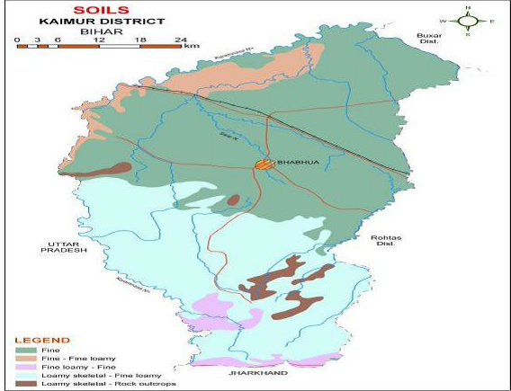
The soils in the northern part of the district are mainly derived from the older alluvium. These alluvial plain soils are greyish yellow to light grey in colour, heavily textured and are neutral to slightly alkaline. The alluvial plain soil is fertile and represents a broad spectrum of sand, silt and humus rich clay. The marginal alluvial soils are found south of G.T. road up to the foothills of Bhabua. These are calcareous soils and are heavy textured. The Bhabua plateau soil is not fertile and are covered with thin forest. These soils are acidic and are light to medium textured. The potash content is medium to high and has low nitrogen.
SOIL EVALUATION
An evaluation of the physio chemical properties of soil from Kaimur district was undertaken to analyse micro -macro nutrients and chemical properties of the soil. Soil samples were collected from farm of 9 villages using soil auger and screw auger and khurpi at the depth of 0-15cm, 15-30 cm and 30-45cm. After sampling the samples were air dried in shade and then these samples were processed for various physical and chemical tests. The data was recorded during the course of investigation were subjected to statistical analysis by analysis of Completely Randomized Design (CRD) as per the method of “Analysis of Variance” (ANOVA) technique.
Study revealed the following features:
- Particle density ranges from 2.61 to 2.85 Mg m-3
- Bulk density ranges from 1.05 to 1.33 Mg m-3
- Water retaining capacity ranges from 37.44% to 63.94%
- Soil textural classes were clay loam, sandy loam and sandy clay loam
- pH value ranges from 6.09 to 8.28
- Electrical conductivity ranged from 0.07 dS m-1 to 0.29 dS m-1
- Nitrogen (N), Phosphorus (P), Potassium (K) ranged from 223.2133 kg ha-1 to 289.45 kg ha-1, 9.744 kg ha-1 to17.8 kg ha-1 and from 82.04 kg ha-1 to 163.607 kg ha-1
- Organic carbon and Organic matter ranges from 1.41% to 1.88 % and 1.49% to 3.12%
The above report clearly indicates that soil has good water holding capacity and has good physical condition and pH and Electrical conductivity was found to be normal. The nitrogen, phosphorus, potassium values are found to be low to medium in all villages. There is an increasing awareness of need to pay greater attention in the role of macro nutrient enhancement in the soil for good soil health and proper nutrition of plant to attain optimum economic yield and soil in suitable for all major tropical and subtropical crops. This information will help farmers to determine economically optimum rates of nutrients application, high yields with low production costs per unit area in modern farming.
Combined application of manures and fertilizers plays a pivotal role in the improvement in soil physicochemical properties, macro and micronutrients distribution and their transformations under different cropping systems. Intensive cropping systems lead to N, P, K, Zn, Cu, Fe, and Mn deficiencies in surface and subsurface soil, which could be refreshed with combined application of manures and fertilizers. The application of manures and fertilizers controls the pH and electrical conductivity of soil. Inclusion of a legume crop in a cropping system can improve soil physical and chemical properties, particularly in predominantly rice cultivating areas.
The foothills of Kaimur consist of alluvial soil and are naturally fertile. Soil nutrients decreases with increasing of depths because of the plant uptake and leaching. Amount of organic matter was medium in soil. pH of the soil plays an important role in soil, amount of macro and micronutrients present in soil depends on ranges of pH. Based on this analysis soil from Kaimur district was good for cultivation and soil is having good fertility and productivity. Wheat, paddy, arhar, gram, lentil, line seed, mustard and vegetables.
like tomato, brinjal, chilli, broad beans, cabbage and cauliflower can grow. Farmers will have to seek a sustainable solution that better addresses integrated soil management. To improve the soil health and reduce the cost of cultivation, the proper integrated soil management should be practiced. Use of organic fertilizer and proper agronomic practices help in improving the soil health.
BEST PRACTICES
Provide balanced doze of fertilizer especially phosphorous and potash to be ensured under late transplanted conditions.
Direct seeding of drought tolerant varieties in dry soil in June/July with pre-emergence herbicide application under sufficient soil moisture conditions.
Raise staggered community nursery preferably with medium duration varieties
Application of organic manure and vermi compost initially for Rice and other crops.
Fodder varieties of Jowar, Maize, Bajra in combination with legumes (cowpea and horse gram) can be taken up wherever feasible to meet the fodder requirements in deficit rainfall districts.
Mulching through mechanical weeding
Soil nutrient & moisture conservation measures
Open the furrow during evening and leave the furrow open overnight and plank in the next morning before sunrise for growing of early Rabi crops like Lentil & Chickpea
SUSTAINABLE FARMING
AGROFORESTRY – has become a popular practice which involves integrating trees and shrubs into traditional farming systems, promoting biodiversity and enhancing overall sustainability.
CROP ROTATION -is another aspect of sustainable farming. This practice helps prevent soil degradation, pest infestations, and nutrient depletion, contributing to a healthier and more resilient farming ecosystem.
RAINWATER HARVESTING – Sustainable agriculture embraces rainwater harvesting techniques, including artificial recharge of groundwater and mulching. These practices help conserve water resources and enhance soil fertility.
INTEGRATED PEST MANAGEMENT – With a focus on pest control through natural means, integrated pest management involves strategies such as cover crops, mulching, and permaculture. These techniques reduce the reliance on chemical pesticides, promoting a more sustainable and eco-friendly approach.